Anaximander was the second philosopher of the Ionian school, which was particularly interested in cosmology. The shape and size of his map are difficult to envisage from the accounts. Whether Anaximander taught that the earth was spherical or cylindrical has also been a point of contention among classical and modern authors, the direct evidence on his cosmology is contradictory. According to Diogenes Laertius, the 3rd century A.D. compiler from whom we derive much of our bibliographical information about ancient Greek philosophers, Anaximander was the first to draw an outline [perimetron] of land and sea and also to have constructed a globe". Similarly, Agathemerus, author of a 3rd century A.D. geographical treatise and a source of many otherwise lost works, claims that Anaximander was the first to venture to draw the inhabited world on a map [pinaki]. The two most common Greek words for a "map", (ges) periodos and pinax, can have other meanings, respectively "circuit of the earth" and "painting". As a result, modern writers have tended to be somewhat cautious in their assessment of Greek cartography. Diogenes Laertius also tells us that Anaximander believed in a geocentric universe with a spherical earth, he is suspect, since the spherical concept was not devised early, and others attributed to Anaximander the different concept of a cylindrical earth. Nevertheless, he may indeed, as Diogenes Laertius claims, have been the first to construct a sphere, though more likely celestial than terrestrial. Anaximander of Miletus is said to have held that the earth was of cylindrical form, like a stone pillar; the inhabited part being apparently the circular upper surface. Some of his astronomical speculations were equally fanciful and unfounded.
The practical map-making which developed from Anaximander's map may be illustrated from a well-known story in Herodotus. In 499-8 B.C. Aristagoras, tyrant of Miletus, made a tour of important cities on mainland Greece looking for allies against Darius I, King of Persia. He took with him on this tour what Herodotus calls "a bronze tablet [pinax] with an engraving of a map [periodos, literally 'going round' of the whole world with all its rivers and seas." Among his contacts was King Cleomenes of Sparta, and on it he showed him all the areas on the way from Ionia to Susa, capital of Persia. The last region of Asia Minor on the proposed march, Cilicia, is described as 'opposite Cyprus', implying that Cyprus too appeared; and the regions east of Asia Minor are given as Armenia, Matiena, and Cissia with the city of Susa. Like many other maps in antiquity, however, this presumably had no scale; for Cleomenes, two days later, asked 'How long would such a march take?' 'Three months', was the reply where upon despite attractive offers of money he refused. This map was probably developed from that of Anaximander. But we may presume that it also contained the course of the Royal Road, which Herodotus describes in some detail immediately after, giving the number of staging-posts and the distances. This road had been carefully measured for the Great King by road surveyors; and the general proportions of Aristagoras' map, particularly the section relating to Asia, may well have been guided by such survey work on it. A plausible theory is that the geographer and mythographer Hecatæus of Miletus was the indirect promoter of this map based on Anaximander and on his own travels in Asia and Egypt.
Herodotus' reference is important in showing that maps could be engraved on portable bronze tablets, that general maps of the inhabited world were frequently made in Ionia, and that they were more informative than the simple geometric plans such as the Babylonian clay tablet of the same era.
It is not certain that Anaximander wrote a commentary on his map or on the construction of his sphere. However, it is clear that Anaximander was the first recorded of that long line of Greek craftsmen-philosophers who tried to express concepts in graphic form. The construction of spheres and the drawing of maps were to become characteristic products of the mechanical mind of the Greeks and their regular occurrence reveals perhaps a more practical side to them than traditionally has been presented.
The first Greek geographical work, written in prose around 500 B.C., was Hecatæus' Periegesis ['Guide Round'] or Periodos Ges ['Journey Round the World' or 'General Survey of the inhabited world as known at that time']. A great part of it was taken up with an account of places and districts bordering on the sea, and it must have borne a considerable resemblance to what was afterwards called a Periplus, or Coasting Survey. It has only been preserved in some 300 fragments, and the majority of these are of the briefest description, having been preserved in the epitome of the work of Stephanus of Byzantium, which gives little more than the names of places with the countries to which they belonged. However, it does appears that, in part of his written work at least, Hecatæus was far from confining himself to a dry geographical description of the country, but discussed at considerable length upon its natural curiosities, and the manners and customs of the local inhabitants. He, however, certainly added a number of mere geographical details, such as are not found in Herodotus' Histories, as we find the names of not less than fifteen cities of Egypt cited from him by Stephanus. When we are told that he enormously improved Aristagoras' map, this probably means that he criticized it in his text rather than re-drew the map.
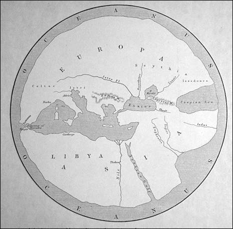
The Periegesis was divided into two books, 'Europe' and 'Asia' the latter also including Libya [Africa]. Hecatæus had travelled in Asia and Egypt, and is said to have made a map, well spoken of by Agathemenus, and probably based upon an "improved" reproduction of the Anaximander map. Modern reconstructions reasonably show this map, which is likely to have accompanied his book, as circular, with the ocean surrounding a landmass which ends eastwards at the Indus River and the Caspian "Gulf". Hecatæus believed that the upper surface of the earth pillar was a curving disc. The Mediterranean Sea was the center of the "world island" composed of lands bordering this sea, the whole being surrounded by a circumfluent ocean-stream. The circular shape of flat maps in the early period was laughed at by later Greeks. Hecatæus is the first writer we know of to think of the Caspian as flowing into the ocean, an idea which long persisted. On the Black Sea, an area colonized by Miletus, he was clearly informative, and his writing may have helped Herodotus on areas like Thrace. To the north of the Danube, according to Hecatæus, were the Rhipæan [gusty] Mountains, beyond which were the Hypernotians [men of the far south]. Ancient and modern opinion has differed on the location of the Rhipæan Mountains; Aeschylus and Pindar imagined that they were at the source of the Danube. In west Africa Hecatæus clearly knew some places on the coast of Morocco. His view of the Nile seems to have been that it came, somehow, from the southern ocean.
In Book Two, comprising the coast of Libya [Africa], from the confines of Egypt to the Pillars of Hercules [Straits of Gibraltar], one finds a mere Periplus, or coast-description. noticing many ports and small islands; while the only tribes of the interior he is known to have mentioned are the Mazyes and Zygantes - obviously the same with the Maxyes and Gyzantes of Herodotus, both of which lived within a short distance of the sea, near the Tritonian Lake. The most distant places that he enumerates towards the west are Metagonium, a name which we find in later times applied to a promontory and people not far from thePillars of Hercules; and Thinga, evidently the same place that was subsequently called Tinga, or Tingis [the modern Tangier], just without the Straits. It is probable also that his river Liza was the same as the Lixus of later geographers, on the Atlantic coast of Mauritania, but this is far from certain.
In regard to the general notions of geography entertained by Hecatæus we are, unfortunately, very much in the dark. It is certainly probable that he was one of those writers whom Herodotus had in view when he censures those who represented the earth as "exactly round, as if drawn with a pair of compasses, and the Ocean flowing all around it." This was clearly the popular contemporary Greek world view concept, derived originally from the Homeric poems; and, from all we know of the progress of the Greek mind, there can be no doubt that they would be very slow to emancipate themselves from the influence of an error once established upon such authority. Anaximander of Miletus, the countryman of Hecatæus, as mentioned above, has been credited in Western literature as the first to draw up a map of the world, and there can be little doubt that this formed the foundation for Hecatæus' map. But though the latter is said to have introduced material improvements on the work of his predecessor, there can be no doubt that both would be still very rude and imperfect attempts, which might well excite the ridicule of Herodotus. In this case, as in so many others, it is probable that the scientific tendency of the Greek mind came into play, and that they assumed the round form of the earth and the circumfluent ocean as first principles, without any actual knowledge of the facts. We are told also that they placed Greece in the centre of the world, and Delphi as the central point of Greece. This last notion appears to have obtained a fixed hold on the Greek mind, and is frequently alluded to by the poets of the 5th century B.C., as a received article of popular faith. Just in the same manner the geographers of the middle ages assumed that Jerusalem was the center of the world, and arranged other countries accordingly.
It was evidently the same symmetrical turn of mind that let Hecatæus to divide the world into two great continents or primary divisions of equal extent. But this question of the division of the continents is not free from difficulty. Herodotus, in the passage already referred to, ridicules those who made Asia of equal size with Europe, in terms which seem to exclude all consideration of a third continent; and Hecatæus, by including all Libya [Africa], as well as Egypt, under the head of Asia, appears to have sanctioned this arrangement. On the other hand, it is clear that the division into three continents was well established in the time of Herodotus, so that he himself tells us that he continues to use the divisions and the names "because they are sanctioned by custom," though he thinks them unreasonable, and without good foundation. And in another place he censures "the Ionians," who divided the world into the three portions of Europe, Asia, and Africa, but considered the last two as separated by the Nile; thus as he points out, leaving the delta unaccounted for. It is difficult to suppose that among these "Ionians" Herodotus did not mean to include Hecatæus - the most recent as well as the most eminent of Ionic writers on geography - or that, if Hecatæus had departed from the generally received doctrine on so important a subject this would not have been noticed by Herodotus. It seems therefore probable that, although Hecatæus undoubtedly divided his work into only two books or parts, the second of which included the description of Libya as well as that of Asia, he nevertheless recognized the established division of the three continents, regarding Asia and Africa together as equal in size to Europe.
At the present day we are so accustomed to our modern maps, and to the small size of Europe, as compared to the other two great continents, that we find it difficult to represent to ourselves the opposite view. But Herodotus undoubtedly regarded Europe as greatly exceeding in size both Asia and Africa together, and, therefore, treats it as a gross blunder on the part of Hecatæus to have considered it as only equal to Asia. One point that doubtless affected the comparison was that Hecatæus regarded the Cimmerian Bosporus and the Tanais [i.e., the Don River] as the limit between Europe and Asia - a view generally adopted in later times - while Herodotus extended the confines of Europe to the river Phasis. Both systems were current in their time, as we learn from the poet Æschylus, who in one passage adopts one view, in another follows the other.
A traveller who had visited Egypt could hardly fail to have formed or adopted some theory concerning the must controverted questions respecting the Nile and its annual inundations, a subject which had already exercised the ingenuity of several of the Ionic philosophers. But on this point Hecatæus appears to have acquiesced in the view which, if we may trust to Diodorus, was that of the Egyptian priests: that the Nile derived its waters from those of the circumfluent stream of ocean - a theory which Herodotus justly sets aside as unworthy of refutation.
A similar want of judgement was displayed by him in accepting, as he appears to have done without scruple, the fabulous tales that were current in his day concerning the Pygmies and the Sciapodes, both which nations he placed in Ethiopia, in accordance with the opinion prevalent among the travelers of the time.
LOCATION: (map only exists as reconstruction)
REFERENCES:
Brown, L., The Story of Maps, p. 25.
*Bunbury, E., History of Ancient Geography, pp. 71, 143-147.
*Dilke, O.A.W., Greek and Roman Maps, pp. 22-23.
Heidel, W.A., The Frame of the Ancient Greek Maps, p. 132.
*Landström, B., Bold Voyages and Great Explorers, p. 30.
*illustrated